The earliest recorded use of a magnetized needle for navigational purposes is found in China in Zhu Yu’s book Pingzhou Table Talks of 1119 (written from 1111 to 1117):
The navigator knows the geography, he watches the stars at night, watches the sun at day; when it is dark and cloudy, he watches the compass.
The invention spreads unbelievably fast for the ancient world, reaching the outskirts of Europe in under a century; in 1187 Alexander Neckam reported the use of a magnetic compass on the English Channel.
The first explanation of how compass works was proposed in a mid-14th century book, Inventio Fortunata, one of the most famous lost books of all time. All we know about it is found in a 1577 letter by Flemish cartographer Gerardus Mercator, retelling its summary from another now lost book, Itinerarium by Jacobus Cnoyen (to make things funnier, neither Cnoyen nor his sources are now thought to have actually seen the Inventio).
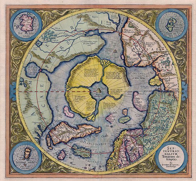
Inventio Fortunata is said to be a travelogue written by a Franciscan friar from Oxford who travelled the North Atlantic region on behalf of Edward III. Most importantly, it contains a description of the North Pole as a magnetic island (“Black Rock”, Rupes Nigra) surrounded by a giant whirlpool and four continents. It gives further sinister details:
In the midst of the four countries is a Whirl-pool, into which there empty these four indrawing Seas which divide the North. And the water rushes round and descends into the Earth just as if one were pouring it through a filter funnel. It is four degrees wide on every side of the Pole, that is to say eight degrees altogether. Except that right under the Pole there lies a bare Rock in the midst of the Sea. Its circumference is almost 33 French miles, and it is all of magnetic Stone.
Rupes Nigra features most prominently on maps from sixteenth and seventeenth centuries. The most specific depiction is on 1539 Carta Marina by Olaus Magnus[1], where it’s named “Insula Magnetum” and placed off modern day Murmansk:

Probably, the most famous and certainly the most influencial image of the island is that on Mercator’s map published in 1587[2]:

References:


Leave a comment